J6 Stevenson: Pont de Monvert - Cassagnas

ARPF
User
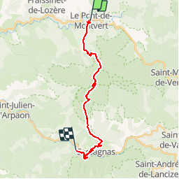

Length
19.7 km

Max alt
1307 m

Uphill gradient
687 m
Km-Effort
29 km

Min alt
697 m

Downhill gradient
865 m
Boucle
No
Creation date :
2015-05-28 00:00:00.0
Updated on :
2015-05-28 00:00:00.0
5h58
Difficulty : Medium

FREE GPS app for hiking
 SityTrail
IGN / Geographical institutes
SityTrail Plus
The world is yours!
About
Trail Walking of 19.7 km to be discovered at Occitania, Lozère, Pont de Montvert - Sud Mont Lozère. This trail is proposed by ARPF.
Description
IE= 77 P3 T1
Positioning
Country:
France
Region :
Occitania
Department/Province :
Lozère
Municipality :
Pont de Montvert - Sud Mont Lozère
Location:
Le Pont-de-Montvert
Start:(Dec)
Start:(UTM)
559246 ; 4912478 (31T) N.
Comments